Gokyo Valley Chola Pass Trek

15 Days

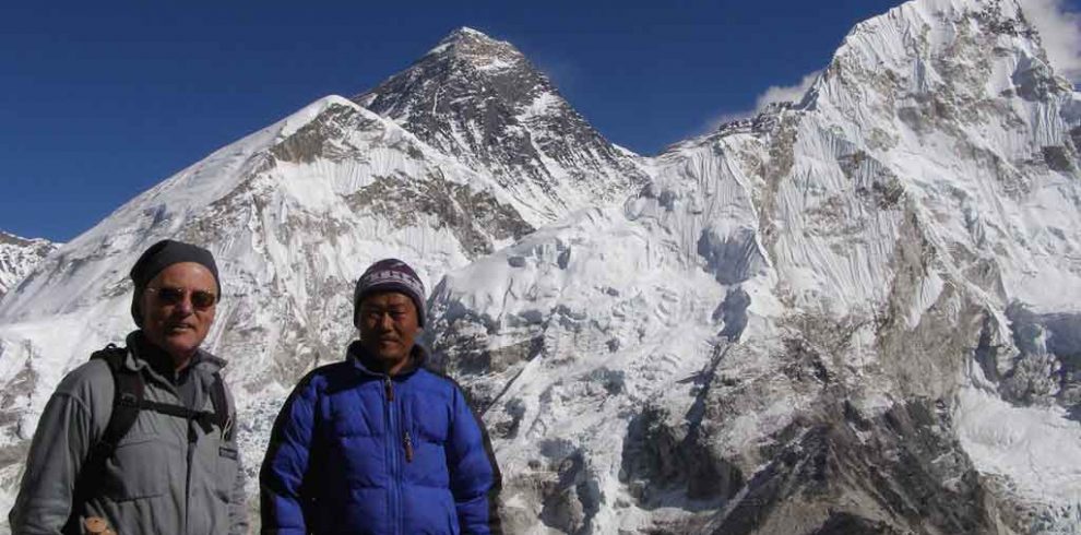
The Gokyo Valley Chola Pass trek is one of the most adventurous treks in the Khumbu region. This unique trek goes through the home of the legendary Sherpa people- Namche Bazaar. The route then passes following the Dudh Koshi River to its source- the Gokyo Lake to the west of the Everest Base Camp.

The trek starts at Lukla reached after a 35-minute scenic flight from Kathmandu. Then we continue towards Namche Bazaar and all the way to Gokyo Valley, Chola Pass and finally Gorakshep. We will continue our journey to the Mount Everest Base Camp and Kalapatthar on the following day. Therefore, the Gokyo-Chola pass-Everest Base Camp trek is also known as the Everest Circuit trek.

Brief Itinerary:

DayRouteAltitudeDuration
01Fly Kathmandu to Lukla, trek to Phakding2,610m/8,563ftTrek: 3-4 hrs
02Trek Phakding to Namche Bazaar3,446m/11,306ftTrek: 5-6 hrs
03Rest and acclimatisation day in Namche Bazaar3,446m/11,306ftFree time
04Trek Namche Bazaar to Dole4,200m/13,780ftTrek: 5-6 hrs
05Trek Dole to Machhermo4,470m/14,666ftTrek: 3-4 hrs
06Trek Machhermo to Gokyo4,790m/15,716ftTrek: 3-4 hrs
07Climb at Gokyo Ri in the morning5,360m/17,586ftTrek: 2-3 hrs
08Trek Gokyo to Thangnak4,950m/16,241ftTrek: 3-4 hrs
09Trek to Dzonglha crossing over Chola pass5,330m/17,487ftTrek: 6-7 hrs
10Trek Dzonglha to Lobuche4,910m/16,109ftTrek: 2-3 hrs
11Trek to Everest Base Camp, return trek to Gorakshep5,364m/17,598ftTrek: 7-8 hrs
12Trek/Climb to Kalapatthar, return trek to Pheriche5,545m/18,192ftTrek: 7-8 hrs
13Trek Pheriche to Namche Bazaar3,446m/11,306ftTrek: 5-6 hrs
14Return trek Namche Bazaar to Lukla2,840m/9,318ftTrek: 6-7 hrs
15Fly Lukla to Kathmandu1,350m/4,430ft35 minutes

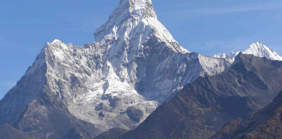
The exceptional Gokyo Valley Chola Pass trek rewards with the panoramic views of Cho Oyo, Makalu and Mt. Everest of course. The dramatic landscape from the summit of Gokyo Ri (5,360m/17,586ft) is truly impressive. One of the major attractions of this trek is the Gokyo Lake situated in the Gokyo Valley.

An excursion to the fourth and fifth lakes would be an extra adventure from Gokyo. Gokyo Ri refers to as the best view point in the entire Everest Region for more spectacular scenery than that from the Kalapatthar. We are then ready for the return trek to Lukla following through the beautiful Thyangboche monastery and Namche Bazaar.

Lobuche or Island Peak climbing is a popular trip extension to this trek.

Gokyo Ri Trek Difficulty

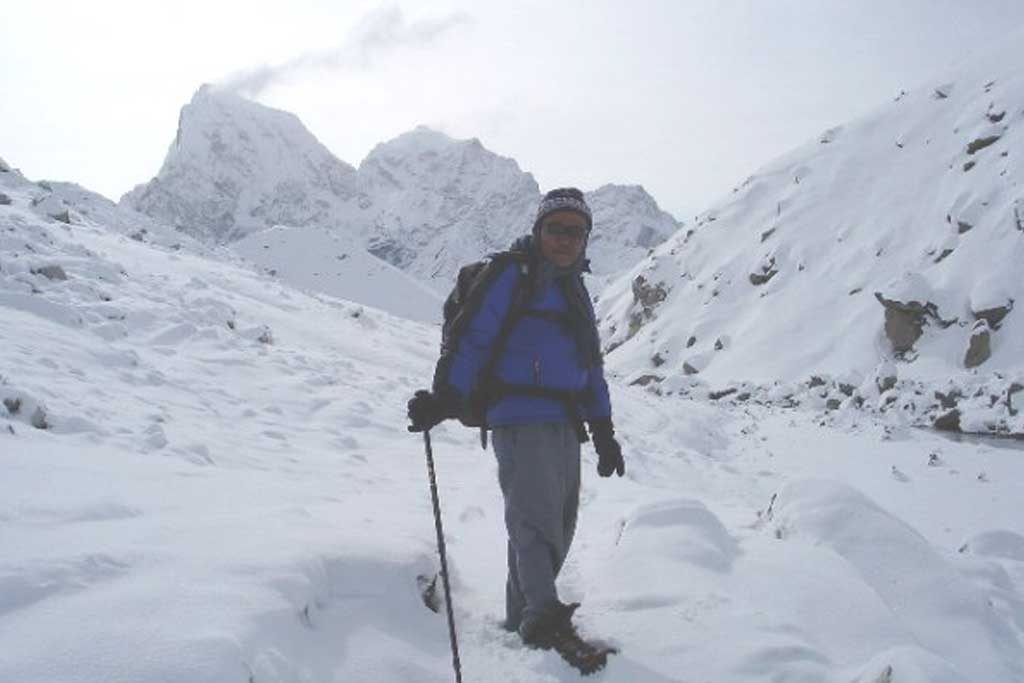
Our Gokyo Valley Chola Pass trekking itinerary is carefully designed so that trekkers can accommodate gradually with the changing altitude. Gokyo Ri lies at an elevation of 5,360 meters and helps a lot in order to acclimatize before crossing the challenging Chola pass.

It is a steep climb up to Gokyo Ri that offers amazing views of Mount Everest, Cho Oyu, Lhotse and Makalu. It takes about 3 hours to reach the Gokyo Ri top and return. The difficulty level of this trek is hard as it involves the Chola pass where part of the trail goes over ice.

On the Chola pass crossing day, it is important to start the trek very early in the morning- around 4 or 5 AM. Your leader will wake you up to begin the adventure. A head torch for each is necessary on this day. Another part of hardness of this trek is the altitude.

It may be beneficial if you have some experience of Himalayan trekking. Exercising regularly at home or hill walking for 5-6 hours a day (if possible) prior to the trip for few weeks can be a great asset. However, your passion is the major reason to make it a real once in a lifetime achievement.

Best Time for Gokyo Valley and Chola Pass Trek

The best time to trek to Gokyo Ri, Chola pass and Everest Base Camp starts from the middle of March to middle of June and from the beginning of September until November. Chola pass remains closed during winter. This part of the trek receives less number of trekkers in summer since the visibility of the mountains is poor due to the cloud in the sky.

Overview

  • The challenging Chola pass (5,330m/17,487ft)
  • The spectacular views from Gokyo Ri
  • The Gokyo valley with the blue Gokyo Lake
  • Magnificent views of Mt. Everest Himalayan range
  • Amazing view of the Khumbu Ice-fall
  • Scenic mountain flight to/from Lukla

Itinerary

We set off early morning from our hotel to domestic airport for Lukla flights. After a 35 minute scenic mountain flight by a small aircraft, we land in Lukla airport (Tenzing-Hillary airport). Today’s trek from Lukla to Phakding is only about 3-4 hours. The trail from Lukla is seen broad and clear. From the airstrip it heads north through a kani (arch) and then slopes downhill to a low agricultural land. A splendid view of the difficult trekking peak Kusum Kangaru (6,367m/20,889ft) is seen while walking ahead. The trail is rich with teahouses, prayer wheels, gompas (Buddhist monastery) and huge boulders decorated with Buddhist mantra (prayer chant). Finally we arrive in the village separated in two parts with about a 10 minute trek between them, and a long suspension bridge over the Dudh Koshi River. This village is called Phakding where we stay overnight.

Today's trek is about 5-6 hours. After crossing the suspension bridge at Phakding, we trek for 2-3 hours following the climbs steeply up rough stone steps before reaching the long paved Monjo village on the edge of Sagarmatha National Park. In addition to the lodges, single-roofed houses and a few basic shops, there is a small gompa nearby. The trek from Monjo to Namche Bazaar will take another 3-4 hours. There is an entrance to the Sagarmatha National Park where an entry permit must be showed or obtained and kept safely for showing on exiting the park. Once passed through the gate, the trail drops to river level which is set among fields of huge cabbages, crosses to the west bank of the Dudh Koshi river on a long suspension bridge and passes teahouses and lodges in Jorsale (2,775m/9,104ft). This is the last available accommodation before Namche Bazaar. About halfway up, at a bend on this ascent we should get our first brief view of Mt. Everest, Nuptse and Lhotse. As our trek continues up mostly among trees, we will eventually come to a group of buildings, then broad stone steps and finally arrive in one of the lower streets of our overnight stop Namche Bazaar. This town is known as the Sherpa “Capital” and gateway to the Mt. Everest. Namche Bazaar has many facilities – a post office, banks, ATMs, money exchange centre, a health post, a dental clinic, numerous shops, restaurants, cyber cafés and telephone facilities, a gompa and several chortens. The headquarters of the Sagarmatha National Park and a military post are situated above the town. We stay two overnights in Namche Bazaar for acclimatization and excursion around. Trekking time 5-6 hours.

Today we stay in Namche Bazaar for acclimatisation. Because of the altitude, it will be necessary for us to spend a minimum of two nights here. On this day, we have the choice of just relaxing and roaming round this interesting hill town, or alternatively trekking round a nearby 3-4 hour circuit with stunning views. This day helps a lot for acclimatisation for our further trek to Gokyo, Chola pass and Everest Base Camp.

Today we start from Namche Bazaar on a trail with gradual ups and downs. We might be able to witness Himalayan pheasants, musk deer and Himalayan Thars on the way. Our trek then enters into the Gokyo valley at Sansa. The trail climbs through rhododendron forest and comes to a point where, for the first time, we will be able to see Mt. Cho Oyu (8,201m/26,907ft) at the head of the valley. The route now makes twisting ascents through woodland, climbs more steeply into the open, crosses a number of streams, traverses a yak pasture with a solitary herder’s hut, crosses a minor ridge and enters our overnight stop, the lodge settlement of Dole. Dole began as a kharka (a yak pasture) with a few herders’ huts, but once Gokyo became a trekking destination, lodges soon established more rapidly. Trekking time 5-6 hours.

Today's trek is a short and pleasant one and we can relax and take things easy. Because of the demands of altitude acclimatisation, we do not go further. Beyond the first of Dole’s lodges the trail goes downhill, crosses a stream, swings right to climb a hillside and crosses pastureland with dry stone walls and several yak herders’ huts. The trail continues past a few stone-built huts and contours along the hillside, descends into a small basin with more walls, stone huts and lodges, then just under two hours from Dole reaches Luza (4,360m/14,305ft) which is also a kharka (yak pasture). Because the lodges at Dole and Machhermo can be very busy in the autumn trekking season, it has become a possible site for overnight accommodation. From Luza, the path climbs out of the northern side of the basin and crosses more pastureland bordered by a chorten and prayer flags. In every direction here the views are spectacular. Eventually the trail slopes down into the valley, crosses a stream and rises up a short slope into the yak pastures and lodges of our overnight stop Machhermo. Trekking time 3-4 hours.

Today will be another relatively short trek across broad pastures, through narrow clefts with steeply climbing trails, past two or three lakes and through an ablation valley beside the Ngozumpa Glacier. An ablation valley is one formed by the melting of glacier ice. The trail climbs round a hillside spur, where lofty Cho Oyu will again come into view and soon we will reach another kharka with some simple lodges. Directly ahead of us at this point, we will see the terminal moraine (ridge of rocks) that closes off the Ngozumpa Glacier. The trail now goes briefly downhill, then climbs through the aforementioned ablation valley on the western side of the glacier, goes steeply up stone steps and crosses a stream on a short wooden bridge. A succession of cairns now marks the route through a stony landscape, with a small tarn (Mountain Lake) on the left. The valley now broadens and the trail reaches a second larger tarn Taboche Tsho (4,740m/15,552ft). Beyond this point the trail passes through a narrower section of the ablation valley and comes to a third tarn Dudh Pokhari (4,750m/15,584ft), with prayer flags on its eastern shore. Dudh Pokhari celebrates a fair every year during Janaipoornima, a popular Hindu festival falls in July-August. Just beyond this lake we will come to our overnight stop Gokyo, the valley’s last lodge settlement. Trekking time 3-4 hours.

We spend two nights in Gokyo to help with altitude acclimatisation. In the morning, if weather permits, we climb the hill that rises above the northern shore of Lake Dudh Pokhari, called Gokyo Ri. The summit is marked by large cairns and prayer flags. Also from the top, Gokyo’s turquoise lake, far below has a picturesque view. An excursion to fourth and fifth lake is recommended for passionate trekkers. Trekking time 2-3 hours.

Today we continue our trek to Thangnak (Dragnag), at a point beyond the southern end of Lake Taboche Tsho, where a cairn marks a fork in the trail, we branch left, make any easy rise across the slope and crest the moraine wall at a saddle. From here we will get a splendid view northwards along the length of the Ngozumpa Glacier to Cho Oyu and also to Cholatse and Taboche in the south-east. The way now descends onto the glacier, weaves round ice cliffs, over rocky humps, skirts small lakes and crosses flats of glacial sand. Here there are impressive views in every direction. Having crossed the glaciers, the route descends into the ablation valley below our overnight stop Thangnak, which consists of three very basic simple lodges and a couple of huts. Trekking time 3-4 hours.

Today the trail climbs steadily to a cairn on the crest of a moraine ridge, descends into a valley and arrives at a rough area of rocks and boulders, sometimes known as Cho La Base Camp and also as Phedi (4,930m/16,175ft) which means “at the foot of the hill”. We will now stay close to the right hand rock wall where cairns indicate the route down. The views ahead will now be magnificent. The steep descent now continues down rocky “steps” to reach an easy path, which will take us to the bed of the valley. The remainder of the trek to our overnight stop Dzonglha is through this beautiful valley and we will be able to enjoy the stunning views. Dzonglha consists of a few simple lodges and camping grounds in a walled enclosure. There is a terrific close view of Cholatse’s north-east face (6,335m/20,785ft) seen from Dzonglha and below to the south lies Chola Tsho lake (4,590m/15,059ft). We stay overnight at Dzonglha. Trekking time 6-7 hours.

Today we continue the trek along the moraine of the glacier. The views of Kalapatthar and Pumori on the way are truly magnificent. The trail now enters the Khumbu valley, crosses to the western side from which one gets a clear view of the massive Nuptse (7,861m/25,791ft) and finally arrives at Lobuche. This is a busy place with trekkers camping in various spots on the far side of the stream and around the lodges. We stay overnight at Lobuche. It can be very cold overnight here. Trekking time 2-3 hours.

Today, we set off to the Everest Base Camp with the trail initially crossing a stream below Lobuche and then progressing along the left-hand side of the valley, before rising to a higher narrower step. Soon we will reach a point where a narrow side valley cuts off to the left. After about 200m it takes us to the “Italian Pyramid”, a stone-built lodge and scientific station which collects meteorological and seismic (earthquake) data. Continuing on, the main trail comes to a more open area, climbs a moraine where edelweiss grows on a slope – crosses a sandy stretch, weaves among heaps of moraine, climbs once again and then drops down to Gorakshep. The trail to Base Camp begins just beyond the Gorakshep Lake, runs for some way along the moraine crest and then appears to descend to the Khumbu glacier. Once in the centre of the glacier, the route signs are somewhat dubious – e.g. the occasional cairn of yak dung! – but we will be okay with our experienced guide. Although Everest Base Camp does not provide a view of the world’s highest mountain itself, tomorrow’s trek will more than compensate for this – today we will get a real close-up of the impressive Khumbu ice fall. The Base Camp can be quite a bustling place with expeditions camping, porters, trekkers and yaks, etc. Having achieved our first goal, and after resting, we will return to Gorakshep for our overnight stay. It consists of three lodges on the rim of a level basin of glacial sand, with the small lake nearby. Tibetan snow cocks chase one another noisily across this sand flat. Although it is very close, Everest is not visible from Gorakshep, however there is a stunning view of the majestic Nuptse, soaring high in the east. We stay overnight at Gorakshep. Trekking time 7-8 hours.

Today’s trip is not only literally the “high point” of our entire trek but it also has the absolutely high point with unbelievable views from the summit of Kalapatthar. The long awaited trek starts around 5.00am. The climb takes about 1-2 hours (depending upon the route chosen) to reach the summit. On the arrival at the summit, one can experience the most fantastic sunrise over Mt. Everest. Kalapatthar is a spur of Pumori (7,165m/23,507ft) and in Hindi means “black rock” which is appropriate. It has two summits and two ascent routes, both paths being clearly visible from Gorakshep. The left-hand path which wriggles its way to the secondary summit (5,545m/18,192ft) takes 1-1:30 hours and the other which zig-zags up the eastern flank to the higher summit (5,623m/18,448ft) takes 1:30-2 hours. Neither route is technically difficult. Another alternative is available which takes in both summits, climb the left-hand trail to gain the lower top, marked with a number of slender cairns and then continue along the ridge scrambling over rocks and reach the higher summit with its flutter of prayer flags. From both summits, a truly incredible panorama is spread before you. Although Everest is of course the main focus of attention, the ice cone of Nuptse which from this view point appears higher than Everest, has stunning beauty. Having really soaked up these incredible views we will return downhill to Gorakshep and then continue our trek down to Pheriche after breakfast. We stay overnight at Pheriche. Trekking time 7-8 hours.

From Pheriche, we leave mountains behind us and the descent takes us through the Tengboche Monastery back to Namche Bazaar. We stay overnight at Namche Bazaar. Trekking time 5-6 hours.

Again we proceed southward, retracing the route trekked on day 1 and 2, crossing and re-crossing the Dudh Koshi at intervals. We stay overnight in Lukla. Trekking time 6-7 hours.

We take the 35 minute breathtaking flight from Lukla.
Option available for extending your trip with Jungle Safari adventure, white water rafting or a trip of your choice.

Cost Includes:

  • Sagarmatha National Park permit and TIMS (Trekkers' Information Management System)
  • Three meals (B/L/D) a day on trekking from teahouse/lodge
  • Accommodations at teahouse/lodge in the mountains
  • An English speaking Trekking Guide
  • A porter shared between two trekkers
  • Staff insurance, salary, food, accommodation and their transportation
  • Regular flights for Kathmandu-Lukla-Kathmandu and ground transfers to/from airport
  • First aid kit box
  • A farewell Nepali dinner with live culture program

Cost Excludes:

  • Bar and beverages bills, bottled water
  • Nature of personal expenses
  • Personal cloths and equipment such as sleeping bag, jacket, boots etc.
  • Insurance for accidental, medical and evacuation
  • Tips to the staff
  • International Airfare and Taxes
  • Kathmandu City Cultural Tour
  • Mt. Everest Flight
  • Jungle Safari in Chitwan or Bardia National Park
  • Bird Watching in Koshi Tappu Wildlife Reserve
  • White Water Rafting in Nepal
  • Bungy Jumping / Canyoning / Paragliding / Ultralight Flight
  • Shopping Tours

You can send your enquiry via the form below.

Gokyo Valley Chola Pass Trek