Annapurna Circuit Trek

20 Days

The Annapurna Circuit trek is among the most popular trekking trails in Nepal. The trail passes following the Marshyangdi River upstream with distinct scenery of rivers, flora, fauna and the mountains of course. This route has become famous because of the spectacular views and cultural diversity along the trek. The lower section of the trail at both ends lie on the lower elevations. It covers with lush green subtropical valleys of villages and terraced farming with predominantly Hindu societies.

Likewise, the villages at higher elevations in Manang and Mustang are influenced by Tibetan Buddhism. We can see a lot of Tibetan cultural influences in the upper Annapurna region. The Annapurna Circuit trek offers a 360 degree view of the mountains as we travel around it. Manang and Mustang refer to as the districts across the Himalayas. A side trip to the highest Lake Tilicho (4,919m/16,139ft) from Manang can be a bonus to really adventurous trekkers.

Brief Itinerary:

DayRouteAltitudeDuration
01Drive from Kathmandu to Besi-Sahar823m/2,700ftDrive: 6-7 hrs
02Trek Besi-Sahar to Bahundanda1,310m/4,298ftTrek: 5-6 hrs
03Trek Bahundanda to Chamje1,430m/4,691ftTrek: 5-6 hrs
04Trek Chamje to Dharapani1,860m/6,100ftTrek: 5-6 hrs
05Trek Dharapani to Chame2,670m/8,760ftTrek: 5-6 hrs
06Trek Chame to Lower Pisang3,200m/10,499ftTrek: 5-6 hrs
07Trek Lower Pisang to Manang3,540m/11,614ftTrek: 4-5 hrs
08Rest and acclimatisation day in Manang3,540m/11,614ftFree time
09Trek Manang to Yak Kharka4,018m/13,182ftTrek: 3-4 hrs
10Trek Yak Kharka to Thorung Phedi or High Camp4,925m/16,158ftTrek: 3-4 hrs
11Trek to Muktinath crossing over Thorung la pass5,416m/17,769ftTrek: 7-8 hrs
12Trek Muktinath to Jomsom2,720m/8,924ftTrek: 4-5 hrs
13Trek Jomsom to Ghasa2,010m/6,594ftTrek: 6-7 hrs
14Trek Ghasa to Tatopani1,190m/3,905ftTrek: 3-4 hrs
15Rest day at Tatopani (Natural hot spring pond)1,190m/3,905ftFree time
16Trek Tatopani to Shikha1,935m/6,348ftTrek: 4-5 hrs
17Trek Shikha to Ghorepani2,860m/9,383ftTrek: 3-4 hrs
18Trek Ghorepani to Tikhedhunga via Poon hill3,210m/10,532ftTrek: 5-6 hrs
19Trek to Birethanti and Nayapul, then drive to Pokhara884m/2,900ftTrek: 3-4 hrs
Drive: 1 hour
20Drive/fly from Pokhara to Kathmandu1,350m/4,430ftBus: 6-7 hrs
Air: 0.5 hour

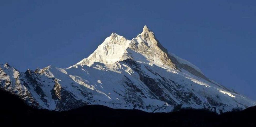
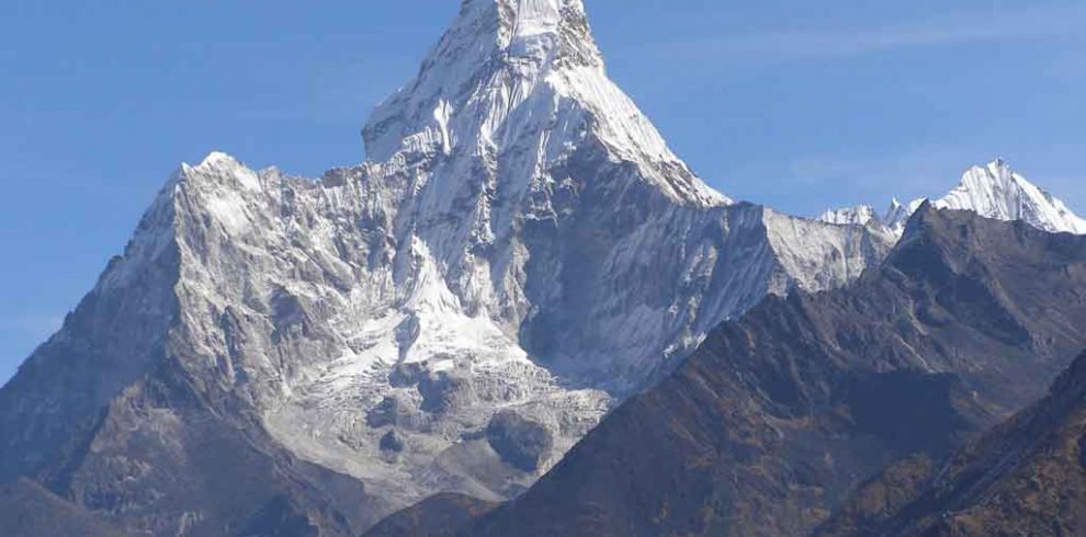
The traditional round Annapurna trek route starts anti-clock from Besisahar to Nayapul and reaches its summit in Thorung la pass (5,416m/17,769ft). The route rewards with the great views of world famous mountains namely Manaslu, Lamjung Himal, Annapurna II, Annapurna IV, Annapurna III, Gangapurna, Annapurna I, Annapurna South, Machhapuchhre (Fishtail) and Dhaulagiri. The world’s deepest gorge and the views from Poonhill make the trek unforgettable.

The trek also passes through Buddhist and Hindu shrines, notably the temple of Muktinath, a holy site for both Buddhists and Hindus. There are also many old monasteries present along the trail. So, we can say that the Annapurna Circuit trek is a perfect blend of adventure and culture making a classic adventure trek. The Annapurna Circuit trek is one of the top twenty scenic trekking trails all over the world.

Why Choose Around Annapurna Trek?

We have accumulated some reasons that make Annapurna Circuit trek distinct.

  • Annapurna region offers gradual ascent including the challenging Thorung la pass at an elevation of 5,416 meters from sea level.
  • The entire Annapurna region covers a diverse topography ranging from high hills to snowy peaks with sub-tropical to alpine forest.
  • Its northern border connects with Tibet and offers views of extended Tibetan plateau where the descendants from Tibet have settled for years.
  • Annapurna Circuit trek passes around the Annapurna Himalayan Range offering 360 degree views along the trek.
  • The Annapurna trail offers a visit to the famous pilgrimage site of Muktinath Temple, worshiped by both Hindus and Buddhists.

Annapurna Circuit Trek Itinerary and Duration

Annapurna Circuit trek was a popular 20-day trip until few years back. The ongoing road construction along the Annapurna trail has reduced its charm though. Most of the places on the trail such as Khudi, Jagat, Chamje, Dharapani, Bagarchhap, Chame, Pisang, Manang, Muktinath, Jomsom, Marpha, Ghasa, Tatopani and Tikhedhunga are facilitated with motorable road.

The road crosses the trail time and again. However, there are options to avoid the motorable roads in some places. Our leaders will try their best to escape the motorable roads where possible and the sceneries are still the same. This is to notify that the weather, transport or other multiple factors can sometimes result in a change of itinerary and trek duration.

Annapurna Semi Circuit Trek

Because of the current road construction project around the traditional Annapurna Circuit trail, this popular trek is losing number of trekkers in the recent years. However, it is still the same between Manang and Muktinath including the Thorung la pass. Enthusiast trekkers can also add a side trip to the Tilicho Lake before crossing the pass and gain some acclimatization.

Therefore, we have thought of Annapurna Semi Circuit trek with a drive further from Besisahar to Chame or Manang. Then the trek starts and continues over the Thorung la pass. Trekking will end at Muktinath, on the other side of the pass. Shared vehicles are available from Muktinath to Pokhara. There is a direct bus facility from Jomsom to Kathmandu if you don’t want to stop in Pokhara.

Please Contact Us for Annapurna Semi Circuit Trek itinerary. The itinerary covers half Annapurna Circuit trek route including the popular Thorung la pass. We will customize this trek according to your vacation. Alternatively, this trek can also be combined with the regulated Nar Phu Valley Trek – 10 Days. Nar Phu will require a separate special permit though.

Difficulty of Annapurna Circuit Trek

The Annapurna Circuit trek is a medium-hard level trip with a challenging pass of Thorung la (5,416m). However, no rope climbing is essential to cross this pass and is suitable for passionate trekkers willing to trek for 5-6 hours each day. This may require walking 6 to 7 hours or more on some days though. So, it gives a pleasure of success over the hardness.

Trekkers with moderate level of fitness can join this trek. We recommend some physical training at home prior to the trip. Jogging or some hill walking if possible is a good idea to enhance your strength and ability. Any previous hiking experience in the Himalayas would be an asset. There are some difficult steps on some days but not impossible.

Can I trek around Annapurna without a Guide?

Annapurna Circuit trek has a friendly route almost everywhere. There are tea shops and lodges at regular intervals. A good map of Annapurna region is advisable for better experience. However, it is not just a walk through the mountains. Due to the missing number of trekkers, it is not suggested to trek alone or without a guide around Annapurna. Safety should be a major concern to everybody.

There are many nice stories behind the settlements and their ethnicity throughout the trail. Notably, it includes the challenging Thorung la pass as well. Having a guide on this trek will facilitate with the information on mountains, plants, animals and people. While it is a high altitude trek, your guide is a great company for any unexpected risks. Also, it will be a support to the local economy hiring a guide.

Best Time for Annapurna Circuit Trek

Like other Himalayan trekking in Nepal, the best time for Annapurna Circuit trek is from March to May and September to November. The Annapurna Circuit route gets busier in spring and autumn but monsoon and winter are quieter. Trekking in winter may not be possible due to ice/snow blockade over the Thorung la pass while trekking in summer is preferred by some trekkers.

Looking for a trek to the more center of Annapurna region?

Then Annapurna Base Camp trek is the best alternative. The 9-day trek starts and ends in Pokhara.

Overview

  • The challenging Thorung la pass (5,416m/17,769ft)
  • Typical Mountain huts in Manang
  • Views of plateau like in Tibet
  • 360 degree views of the Annapurna Himalayan Range
  • The famous pilgrimage site of Muktinath Temple
  • Great view the of Dhaulagiri Ice-fall
  • The world’s deepest Kaligandaki gorge
  • The natural hot spring pond at Tatopani
  • Impressive Sunrise and Panoramic views from Poonhill
  • The great country sides, landscapes, mountains and rivers


Today we drive for 175km (109 miles) by bus or car to the small township of Besi-Sahar, the starting point for our Annapurna Circuit trek. Here we will have to present our entry permits at the check post. This is a scenic drive on the bank of the Trisuli and Marshyangdi Rivers. We pass through the beautiful villages along the way.

After an overnight stay in Besi-Sahar, we start the trek to Bahundanda passing through the villages of Bhulbhule (840m/2,756ft) and Ngadi (930m/3,051ft). It should take around 5 to 6 hours from Besi-Sahar to Bahundanda.

We continue our trek and after approximately 3 to 4 hours we reach the village of Jagat (1,314m/4,311ft) having passed through three other villages: Khanigaon (1,170m/3,839ft), Ghermu Phant (1,180m/3,871ft) and Syange (1,100m/3,609ft). From the village of Jagat which is tightly packed on a natural shelf among huge boulders and a few banana trees, it will take us approximately an hour to reach our overnight stop, the small paved village of Chamje. On this last stage of the day’s trek we will get views of a very fine waterfall on the Chhahare Khola tributary on the eastern side of the valley. Trekking time 5-6 hours.

Today’s trek starts through a gorge and goes downhill to a suspension bridge which crosses the Marshyangdi river to the east bank, then climbs steeply and it proceeds to Tal (1,700m/5,577ft) with its safe drinking-water station. After some downs and ups, we re-cross the river and enter Dharapani village for our overnight stay. Trekking time 5-6 hours.

Today, proceeding on from Dharapani, we pass through the village of Bagarchhap (2,164m/7,100ft) – also with a safe drinking-water station – then on to Danaqyu (2,300m/7,546ft) from which there are good views of the Mt. Manaslu peak (8,163m/26,782ft). From here we proceed to Lata Manang (2,454m/8,051ft) and then pass through some landslide areas and pine forests to arrive at the two-part village of Koto (2,600m/8,530ft). A further easy half-hour stroll takes us into the town of Chame – with a safe drinking-water station – led in by a long mani (a Buddhist prayer wall) studded with prayer wheels. Snow-capped Annapurna II (7,937m/ 26,040ft), which overlooks the town, is a striking picture in the morning sunshine. Trekking time 5-6 hours.

Today’s trek takes us through the villages of Talekhu (2,720m/8,924ft), Bhratang (2,850m/9,350ft) and Dhikur Pokhari (3,185m/10,449ft) en-route. The entrance to Tibetan-style Bhratang has a long mani wall and many prayer flags, likewise Dhikur Pokhari, which also has cairn-shaped Buddhist shrines known as “chortens”. The trekking route then takes us directly to Lower Pisang, from which if desired a diversion can be made to Upper Pisang, the original village. Lower Pisang also has a long mani wall in its centre and a safe drinking-water station. Looking to the northwest from Lower Pisang, one can see the snow-capped “Trekking Peak” Chulu East (6,584m/21,602ft). Trekking time 5-6 hours.

After an overnight stay in Lower Pisang, the trail then continues through the villages of Humde (3,280m/10,761ft), Mugje (3,482m/11,424ft) and Braga (3,360m/11,024ft). Humde is an important village on account of its STOL (short-take-off and landing aircraft) airstrip and police check post. It also has a safe drinking-water station. On leaving this village, the trail is as wide as a jeep track, which makes it easy underfoot and makes the walk to the small village of Mugje very enjoyable, with striking views of the two “Trekking Peaks” Chulu East and Chulu West, both above 6000 meters (19,685ft). Braga, also known as Bhraka, contains a number of Tibetan-style houses and the “gompa” (Buddhist temple) in the village is one of the most distinguished on the Annapurna circuit – well worth a visit. Finally, we arrive in Manang, the main village of the upper valley and one in which the majority of the inhabitants are more closely related to the people of Tibet. Trekking time 4-5 hours.

Manang - the main village of the upper valley has a safe drinking-water station, a museum, surprisingly a cinema hall, and most importantly a Himalayan Rescue Association health post. Here at 3pm every afternoon, a volunteer doctor gives a speech on high altitude sickness. There is no charge for this and it is strongly recommended for those who have not previously experienced high altitude adventure. We may spend our day with excursions around the Manang village.

Today’s trek heads out of Manang via an old "kani" (a covered Buddhist archway) and after 30 minutes or so takes us through the village of Tangki (3,642m/11,949ft). After which the trail heads north-west with a view of Tilicho Peak (7,134m/23,406ft) in the west. Then we reach the small settlement of Gunsang (3,900m/12,795ft). Proceeding from here to Yak Kharka, there are very few steep ascents, but some magnificent views both fore and aft and interestingly, herds of blue sheep (Jharal) may sometimes be observed on the hillsides. As its name suggests Yak Kharka is located on a yak pasture – yak being a species of Tibetan ox. We stop at Yak Kharka for our overnight stay. Trekking time 3-4 hours.

Starting off today the trail crosses a broad yak pasture, then having dropped into a gully to cross a side stream it makes a short steep climb into the settlement of Ledar (4,200m/13,780ft), also situated on a yak pasture and with a safe drinking-water station. From here there is a superb view of the Trekking Peak of Chulu West (6,419m/21,060ft) and other peaks in this range. After a short walk from Ledar the trail forks right, to the east flank of the valley, on a new route created by ACAP, because the west bank trail has become dangerous. We arrange our stay either at Phedi (bottom of the mountains) or climb a little to high camp. Trekking time 3-4 hours.

Today we start our trek very early in the morning and shortly after setting off from Thorung Phedi or High Camp and traversing a steep scree slope, the trail enters a valley with a big moraine wall on the right (“moraine” being a ridge – like mass of earth, rock and stones deposited by a glacier in times past), crosses a stream and then continues to a simple teahouse at 5,100 meters (16,732ft). From this point the trail winds along among a series of moraine hillocks and then approaches the Thorung La Pass on a broad comparatively gentle slope. The pass is reputedly the world’s highest, with the track peaking at 5,416m (17,769ft) – the highest point on the Annapurna circuit trek. In the pass there is another simple teahouse, which to quote, “can be a life-saver”. After the long downhill trek from this point en-route to Muktinath, one eventually reaches a simple lodge. This is the only point west of the pass where refreshments are available before reaching Muktinath (3,760m/12,336ft), a village set in a grove of poplars and which is revered by both Hindus and Buddhists, attracting large numbers of pilgrims from all over the world. Trekking time 7-8 hours.

On today’s trek we first of all pass through the impressive medieval village of Jharkot (3,550m/11,647ft), built around the ruins of a mud-brick fortress. In addition to a Buddhist temple (gompa) and a covered archway (kani) and a Buddhist prayer wall (mani) the village has a post office, a traditional medical centre and several lodges. Continuing on through the picturesque valley of the Jhong Khola (River) we pass the small settlement of Khingar (3,280m/10,761ft), which boasts some lodges. A short distance further on we come to the “Romeo and Juliet” lodge. From this point the trail crosses a broad open scrub plain which is as wide as a jeep track and very easy underfoot. About a couple of hours after leaving Muktinath the route forks and we take the right-hand path for Kagbeni (2,800m/9,186ft), a medieval Tibetan – style village which has a few shops, a health post, post office, a police check point, an ACAP information centre and a safe drinking-water station. Kagbeni is the entry point for Upper Mustang region. From Kagbeni, we continue our trek further to Jomsom passing through the village of Ekle Bhatti (2,740m/8,990ft). Jomsom (also known as New Fort) contains facilities, including shops, banks, police check post, ACAP information office, a hospital, safe drinking-water station, post office, airline offices and even an airstrip. Trekking time 4-5 hours.

After leaving Jomsom the road forks and we take the right branch to the small village of Syang (2,820m/9,252ft) which has an active Buddhist temple and on its outskirts a number of small terraced fields. From here we proceed through the attractive village of Marpha (2,670m/8,760ft). In addition to numerous whitewashed buildings, there is a decorated Buddhist archway at each end of the village. En-route from Marpha to Ghasa we will pass through no less than eight villages. The first of these is Tukuche (2,590m/8,497ft). It has a post office and a safe drinking-water station. Next is Kobang (2,580m/8,465ft) which incorporates a tunnel system, apparently created to protect the buildings from the strong winds in the valley. Carrying on, we arrive at Larjung (2,550m/8,366ft) which differs greatly from Kobang and which has a safe drinking-water station. Having eventually negotiated this stretch of the trek we reach the strip-like village of Kokhethanti (2,545m/8,350ft), with striking views of Dhaulagiri, the world’s 7th highest mountain with a huge graceful peak at 8,167m (26,795ft). Now continuing southward on the left bank of the river, the trail climbs a slope on broad stone steps and then goes downhill to the village of Dhampu (2,502m/8,205ft), a line of stone-built houses. From here the trail continues along the narrowing valley and via a suspension bridge, crosses to the right hand bank and soon enters Kalopani village (2,530m/8,391ft) which almost merges with the nearby strung-out village of Lete (2,480m/8,136ft), which has a health post and a safe drinking-water station. Following on through a stand of pine trees, the track drops steeply to a suspension bridge across the Lete Khola tributary. After a short walk from here we first reach the tiny settlement of Dhaiku/Kaiku (2,085m/6,841ft) and then shortly afterwards the three-part village of Ghasa, our overnight stop. A paved trail links the three sections and between the first and second it continues between walled fields, passing chortens and mani walls. South of Ghasa, Tibetan Buddhism gives way to the Hindu faith, although Buddhism still survives in the area, albeit at a reduced level. Ghasa has a safe drinking-water station situated in the second section. Trekking time 6-7 hours.

A few minutes after leaving Ghasa, the trail crosses a suspension bridge to the left bank and then switchbacks high above the river. For a considerable distance south of Ghasa, landslides in the River Kali Gandaki gorge occasionally necessitate the route being switched from one bank to the other. Just under an hour from lower Ghasa we will come to the small two-part settlement of Pairothapla (1,890m/6,201ft) and then after a further thirty minutes or so on a steep descent in a landslide area, we reach Kopchepani, below which we change sides again by crossing a long suspension bridge to the west bank. Continuing on, we pass the beautiful Rupse Chhahara (waterfall) and then after crossing a wooden bridge arrive at the village of Rukse/Rupse (1,560m/5,118ft) where there are orange, lemon and banana trees and fields of maize on the steep hillside. Ten minutes beyond Rupse, in the now widening valley, we pass through the long settlement of Titre (1,630m/5,348ft) and reach the large three – section village of Dana (1,400m/4,593ft), which was once an important trade centre. In its final section there are a number of thatched houses and also from this point, excellent views of Annapurna South can be seen. After crossing another suspension bridge – over a tributary - and passing through the small settlement of Guithe (1,630m/5,348ft), we arrive at the popular busy village of Tatopani, an ideal place for a rest day, which is in fact what we will be having tomorrow. Trekking time 3-4 hours.

The name of this village literally means ‘hot water’ which is appropriate as down by the riverside there are two pools of steaming hot water in which one can relax, but not bathe or do laundry, the water must be kept free of soap. In addition to a street lined with shops, the village has a post office, a telephone facility, a police check-post and a health post.

Following the welcome day’s relaxation in Tatopani we head south, with the trail climbing a stairway of stone steps, and after a while we will come to a long suspension bridge which takes us across the Kali Gandaki River to the left bank, from where we enter the small village of Ghar Khola (1,175m/ 3,855ft) located on the tributary of that name. We now cross the Ghar Khola Bridge and fork left away from the main (Beni) trail and climb a steep hillside with terraced fields and exotic trees. At the next fork we bear right and ascend a formidable seemingly endless stairway of stone slabs. Then from Tatopani the trail leaves the forest and we first reach Santosh Hill (1,500m/4,921ft) – with excellent views to the north and south – then the settlement of Birauta and after a short trek arrive at the village of Ghara (1,700m/5,577ft) which has several teahouses and shops. From here we have a continuing climb to reach our overnight stop Shikha. This substantial village is built on ascending levels with teahouses and lodges in the lower part and a few simple shops and a school in the upper region. It also commands striking views of both the high mountains and the surrounding terraced lower levels. Trekking time 4-5 hours.

Today the trek continues to climb and after a while leaving Shikha we pass through the small settlement of Ghopte Kharka from where there are more sightings of Dhaulagiri. Next we reach Phalante (2,270m/7,448ft) with its large school, one shop, a teahouse and two lodges. Further ahead we arrive at Chitre where refreshments are available. The last section of today’s trek from here is still uphill and finally it will take us to Ghodepani/Ghorepani, a bustling village with shops, lodges and camp grounds and because of the attraction of nearby Poonhill (3,210m/10,532ft), the route at this point is the most heavily trekked in Nepal. Trekking time 3-4 hours.

A Poonhill sunrise is one of trekkings not-to-be-missed experiences – it is unique. Therefore as the climb to the summit, among rhododendrons, takes about one hour, we will set out on a path from the centre of the village at least one hour before sunrise. There is a lookout tower on the highest point and below it is a very welcome tea station. Having enjoyed this experience we will then head off for Tikhedhunga after breakfast at Ghorepani. The trail passes pleasantly through rhododendron forest and descends at Ulleri village (1,960m/6,430ft) and reaches to Tikhedhunga (1,540m/5,052ft) where we stop for overnight rest. Trekking time 5-6 hours.

Descending from Tikhedhunga via Birethanti (1,040m/3,412ft) to Pokhara, one can see mules loaded with goods en-route. There is a small Walk up to Nayapul (New-bridge) from Birethanti and we take a drive for one hour to Pokhara by bus or taxi (42km). We then check in to a hotel in Pokhara. We become relaxed in Pokhara after the long trek. Trekking time 3-4 hours.

We are more relaxed in Pokhara with the beautiful morning and later we drive or fly back to Kathmandu. Regular tourist buses leave at 7am.

Option available for extending your trip with Jungle Safari adventure, white water rafting or a trip of your choice.

Cost Includes:

  • Annapurna Conservation Area (ACAP) permit and TIMS (Trekkers' Information Management System)
  • Three meals (B/L/D) a day on trekking from teahouse/lodge
  • Accommodations at teahouse/lodge in the mountains
  • An English speaking Trekking Guide
  • A porter shared between two trekkers
  • Staff insurance, salary, food, accommodation and their transportation
  • Land transportation from Nayapul to Pokhara by Taxi
  • Kathmandu-Besisahar overland transfer by public bus and Pokhara-Kathmandu transfer by Tourist bus
  • First aid kit box
  • A farewell Nepali dinner with live culture program

Cost Excludes:

  • Bar and beverages bills, bottled water
  • Nature of personal expenses
  • Personal cloths and equipment such as sleeping bag, jacket, boots etc.
  • Insurance for accidental, medical and evacuation
  • Tips to the staff
  • International Airfare and Taxes
  • Kathmandu City Cultural Tour
  • Mt. Everest Flight
  • Jungle Safari in Chitwan or Bardia National Park
  • Bird Watching in Koshi Tappu Wildlife Reserve
  • White Water Rafting in Nepal
  • Bungy Jumping / Canyoning / Paragliding / Ultralight Flight
  • Shopping Tours

You can send your enquiry via the form below.

Annapurna Circuit Trek
17% Off
From $1,250 $1,040
/ Adult
  • Drive in KTM-Besisahar, Drive out Nayapul-Pokhara
  • 5,416 meters
  • Medium-Hard

Recent Posts